Olympia Practical Cycling Guide
About this guide…
This is an incomplete first draft. As of this writing (8/20/20) the routes are incomplete and inconsistent, and I’m still figuring out the format.
What is this? This is a guide for how to get around the Olympia-Lacey-Tumwater area by bicycle.
Who is it for? People who ride bicycles. In particular, I wanted to write a guide that would help people in the area who are new to cycling and for whom the official bicycle map might not be very helpful (because although it tells you where you can cycle, it doesn’t tell you which routes are good).
How did I pick the routes? Mostly, I went by routes that I have figured out on my own. I do have some preferences, though:
- I would rather ride on a quiet neighborhood street without a bike lane than on a busy street with a bike lane (and prefer a protected bike lane or trail over both), so a lot of routes will be going through neighborhoods.
- Decades of riding have instilled a dislike of hills, so I chose easier grades whenever possible. When there is a harder, but significantly more direct route, I have tried to list it in the Alternate Routes section of the given route.
- I like riding in the shade, so I’m willing to go a bit out of my way for tree cover.
- I tried to avoid busy streets as much as possible. Although when I’m on my own, I have a pretty high tolerance for risk, but when I ride with my kid, much less so. I tried to include routes that I would be comfortable towing a kid in a trailer on.
To Do
This is an incomplete first draft, so there is a ton of stuff that I need to do:
- Finalize termini.
- Write up routes for the remainder of the connections.
- Downtown to Eastside
- Downtown to Tumwater
- Eastside to Westside?
- Eastside to Lacey?
- Lacey to Tumwater
- Lacey to Hawks Prairie
- Ride all of the routes to make sure that I got them right.
- Work on improved map images.
- Create and link to proper routes on a real mapping site.
- Add a big map to the beginning of the page once the basic routes are all done.
Locations
- Downtown Olympia Olympia Timberland Library
- Westside Olympia mall?
- Eastside Olympia San Francisco Bakery/Roosevelt Elementary?
- Lacey Target
- Tumwater Department of Health / WA State Offices
- Hawks Prairie LA Fitness compound?
The Routes
Downtown Olympia to Lacey
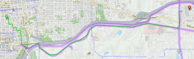
Start: Olympia Timberland Library
End: Lacey Target
Distance: 3.9 miles
Elevation Gain: 220 feet
This is a really straightforward route, and is a pleasant ride, to boot. Once you’re on the Woodland Trail you’re good to go. Getting to the trail is a bit tricky, however.
The Route
- Head South from the Olympia Transit Center. It isn’t terribly important which street you take, all of them are pretty calm since almost all traffic ends up on Capitol or Plum, but I usually take Franklin (which has the benefit of going right by the library).
- I usually jog East after passing the library, so that I’m crossing Union at Jefferson. This is the least pleasant part of the ride. The post office on Jefferson generates sums traffic and Union is a busy street. If you continue to follow Jefferson, there is a bike lane, but I find it much more pleasant to ride half a block East on Union and go up Cherry, which allows you to take quiet neighborhood streets all the way to the Woodland Trail connector(?)
- The connector will take down a hill and up the other side until it terminates at Eastside St., where it terminates. Although there is no signage, if you look to the right you can see the entrance to the Woodland Trail. Take the bike lane and ride up a bit more of a hill and you will be ready to get on the trail.
- Once you’re on the Woodland Trail, you will quickly see why it forms one of the backbones of cycling infrastructure for the area. Eastbound, it is uphill the entire way, but with such a gentle grade that you might not even notice it. In addition, it runs through forest for almost the entire distance, making it a pleasant ride even on hot days. Take the trail until you reach the connection with the Chehalis Western Trail.
- Head north on the Chehalis Western Trail by taking the third exit on the bike roundabout (there should be more bicycle roundabouts in the world). The trail has its own overpass over Pacific, which is really nice, and there are several exits directly into the Target parking lot.
Getting Back
This route is almost exactly the same on the way back. Just get back to the Woodland Trail and you’ll be back downtown in no time. Although the grade is barely noticeable on the way out, the slight downhill will speed things up on the way back.
Alternatives
- 4th to Eastside
Points of Interest
- Centennial Park
- Yashiro Japanese Garden
- Capitol Campus
- Olympic Cards & Comics (Gabi’s)
- As a general rule, Lacey has better ethnic food than Olympia, which makes sense given that it is more diverse. If you’re looking for something to eat, Safuras has some super tasty schawarmas near the end of the route.
Notes
- The trail is not lit, and I have seen evidence of unhoused communities in the woods. Personally, I have ridden the trail as early as 6 am and as late as about 1 am and have never run into any trouble or felt unsafe in anything other than an abstract sense. However, I can totally imagine not wanting to ride this alone at night. Then again, if you are out riding at 1 am, riding through mostly deserted streets without cars around is a real treat, so you might want to skip the trail anyway.
- At the north end of the Target parking lot is an entrance onto the I-5 Trail. If you head west on it, it will take you through a cute little park which is a nice place for a picnic (I-5 park) and let you out on 3rd Ave, which you can follow to St. Martin’s University, Lacey City Hall, and the Lacey Timberland Library (all across College St.).
Last updated: 2020-08-20
Downtown Olympia to Westside Olympia
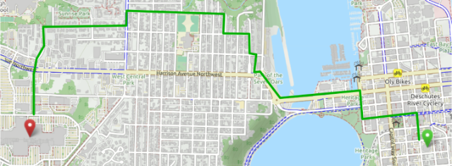
Start: Olympia Timberland Library
End: Capital Mall
Distance: 2.6 miles
Elevation Gain: 213 feet
It is a bit ironic that one of the best-marked routes on this list is also one of the most intuitive. This route really reminds me of The Wiggle in San Francisco, which passes is a winding valley that allows you to get from downtown to Golden Gates Park with a total climb of 120 feet. Granted, the climb here is more like 300 ft, but the instructions are the same, whenever you have the choice between steep and less steep, take the easier route.
The Route
- Start by riding up the 4th Ave bridge to the first roundabout, take the bike lane up to the second roundabout, and cross West Bay Drive.
- From here it looks like you have a grueling climb up Harrison, but about 60 meters past the roundabout you come to Sherman, which is a markedly easier grade.
- From there, you zigzag through the Westside neighborhoods until you get to Division, and from there the grade is pretty flat to wherever you need to go. Signage is good on this route (with one exception where the sign appears to point into an alley), follow it and you’re good to go.
Alternatives
- If you want to challenge yourself, at the first roundabout you can take Olympic Way to 5th Ave and climb straight up. There’s much less traffic here than on 4th or Harrison, so safety and dignity (should you rethink your choice of routes midway through) are improved.
- For an easier climb, Olympia has good, free bus service and the busses have bike racks. No judgements, honest. Public transit is the next best thing to cycling, in my book.
Points of Interest
- The Garfield Overlook trail is my favorite walk within city limits. Do yourself a favor and check it out.
- The Westside Food Co-op is just off the route. It’s smaller than the Eastside location, but nice.
Notes
- If you’re thinking that you can get to Trader Joe’s or Barnes & Noble from here, that’s technically true, but there isn’t anything resembling a good route. I usually take Division/Black Lake Blvd until the bike lane runs out then hop on the sidewalk to get down the hill. Riding on the sidewalk is something that I believe adult cyclists should almost never do, but this part of town is clearly not designed for anyone not in a car. There’s probably a bus that’ll get your there, but I honestly just avoid the place these days.
Last updated: 2020-08-20
Lacey to Hawks Prairie

Start: Lacey Target
End: Hawks Prairie Commercial District
Distance: 4.9 miles
Elevation Gain: 82 feet
This route is one of the reasons I’m writing this guide, since it took some doing to figure out and isn’t at all intuitive. As far as I can tell, there isn’t a good direct way to get to Hawks Prairie by bicycle from… anywhere, really. I’m guessing that it has something to do with it being a more recently developed area, so while there are places with bike lanes, very few of those bike lanes are somewhere where I would want to ride, either being in an area that isn’t really connected to the rest of the bike network or being painted onto the side of a busy road (I’m not very risk averse when I’m riding alone, but even without my kid in tow, I’m not going to ride on the side of Martin Way).
The Route
- Starting at Target in Lacey, hop on the Chehalis Western Trail and head south (left). When you get to the bike roundabout, take another left so that you are heading east on the Woodland trail.
- The trail is pretty easy to follow, with one exception. When you reach the first roundabout where Lacey splits off from Pacific, it looks like you can go either way around the roundabout, but staying on the right-hand side of the roundabout feels less awkward to me. Eventually, you will come to a second roundabout, a 5-way one where Lacey converges back in with Pacific. Once you follow it around the trail splits with the right fork heading to the Woodland Creek Park and the left fork continuing for 100 feet or so. Take the left fork and continue on the sidewalk until you reach Carpenter Rd., where you will make a left.
- Along Carpenter there is one of those weird sidewalks that doesn’t know whether it wants to be a sidewalk or a bike path, since it is almost wide enough. It’s not the sort of thing I normally ride on, on principle, but not hiding in dangerous traffic is the superceding principle here. Fortunately, there is almost never anyone walking here, so it hasn’t been an issue.
- Don’t take the first street you come to (6th Ave), it will just loop back to Pacific. The second street (5th Way) connects, but there are some unpleasant hills if you take that route. What you want is Husky Way, which is almost all the way to Martin (literally, it is like 100 feet before the intersection). Take a right on Husky.
- Follow Husky to Wildcat and take a left, follow the curve right, then take a left on Ranger. When you cross Martin, Ranger becomes Hensley (because of course it does) and you then get to the part where I always get lost and have to look at a map.
- Take your first right on 11th, which curves to the left and turns into Home (St? ), then take a right on 13th Ave. Follow that pretty much to the end, where you can take a left on Ivy or Clover (either one works) then a right on 13th Way (yeah, I know, it doesn’t make sense that there are two 13ths here, but that is residential street names for you).
- 13th Way goes for a very short distance, then becomes a brief, curvy trail with very bumpy asphalt pushed up by tree roots. From here you can cross the street to get your kid’s hair cut or go get a burger or something. Congratulations!
Alternatives
- Yeah, it would be a lot more direct to take Martin, but having ridden on Martin, I’m hesitant to do so again, especially if I have my kid with me.
Points of Interest
- The Woodland Creek Park is really nice. It has a good playground and a disc golf course (though I have never disc golfed, so no idea if it’s any good). Definitely a nice place for a picnic.
Notes
- I ended this route at the strip mall area where Jack & Jill’s is located, there is a bunch of stuff around here, including Fred Meyer, Costco, and Best Buy, all pretty easy to get to by bike. This area is a pretty reasonable alternative to the mall, but is definitely car-centric.
- I need to do some exploring to see if I can find a way around using the sidewalks on Pacific, maybe following the right fork and taking Carpenter from there?
- Check to see if Husky is really better than 5th
Last updated: 2020-08-27